
August Begins with Damaging Wind & Flash Flooding Threat in West Alabama
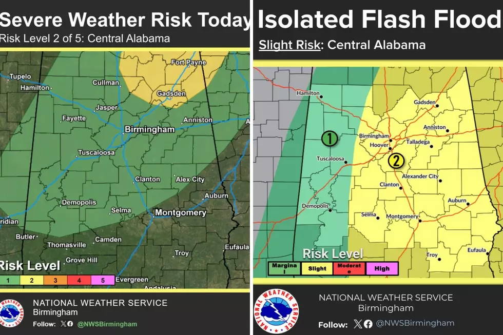
The first weekend in August will bring the potential for active weather to West Alabama, as a large weather system extending from southeastern Indiana and southwestern Ohio down to central Mississippi and much of Alabama moves through the region.
Threat Level and Area
For Saturday, August 1, the Storm Prediction Center has issued a Marginal Risk – Level 1 out of 5 for all of West Alabama counties, which includes Bibb, Fayette, Greene, Hale, Lamar, Perry, Pickens, Sumter, Tuscaloosa, and Walker.
Timing
The timing for these strong to severe storms is today, Saturday, August 1, from 3 p.m. through 11 p.m.
Possible Threats
Residents should expect “numerous to widespread showers and storms this afternoon and evening, with a low risk for isolated damaging wind gusts,” said the National Weather Service in Birmingham.
- Damaging Winds
- Gusts up to 60 mph
- Isolated Flash Flooding

West Alabama Isolated Flash Flooding Threat Areas
The National Weather Service in Birmingham said that “pockets of heavy rainfall may result in isolated flash flooding Saturday and Saturday night.”
“With very high precipitable water values, stronger storms will drop lots of rain in a short amount of time. Some localized flooding issues are possible,” said James Spann, Alabama Weather Network Chief Meteorologist.
Bibb: Risk
Fayette: Marginal Risk
Greene: Marginal Risk
Hale: Marginal Risk
Lamar: Marginal Risk
Perry: Slight Risk
Pickens: Marginal Risk
Sumter: Marginal Risk
Tuscaloosa: Split between Marginal Risk and Slight Risk
Walker: Split between Marginal Risk and Slight Risk
Mary K. – Weather Forecaster
LOOK: Iconic buildings from every state
Gallery Credit: Stacker
LOOK: 25 must-visit hidden gems from across the US
Gallery Credit: Abby Monteil
More From 92.9 WTUG