Alabama Father’s Day: Tornadoes, Damaging Winds, Hail, Flooding
____________________________________________________________________
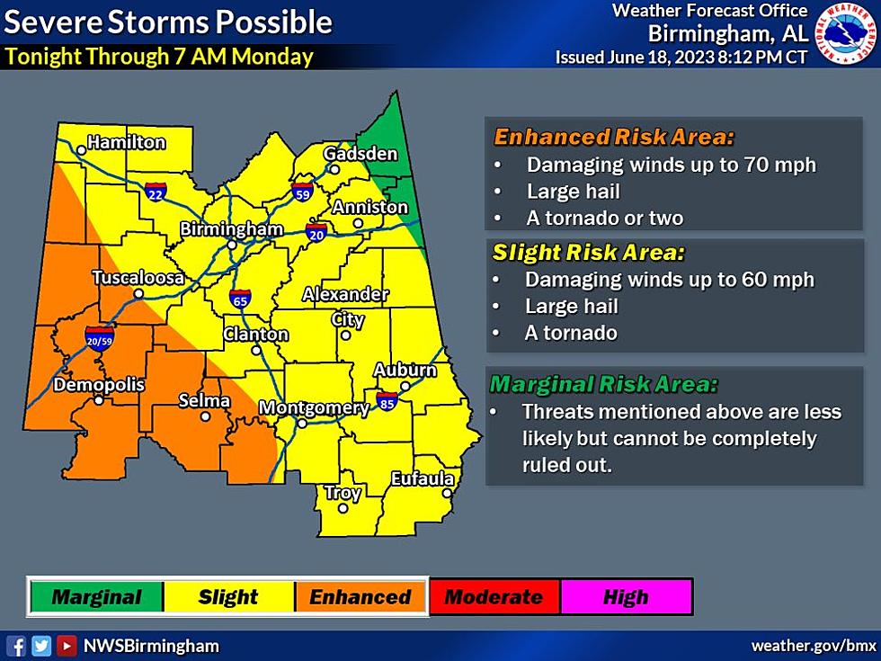
The National Weather Service in Birmingham said that "severe storms remain in the forecast tonight over Central AL. The evening update notable expanded the Enhanced area into Lamar Co. Damaging winds, hail, and a couple tornadoes will remain possible overnight beginning after 9 pm and continuing through morning."
_____________________________________________________________________
There is a Flood Warning for the Sucarnoochee River at Livingston [AL] till further notice.
_____________________________________________________________________

There is an "Areal Flood Watch" valid at Jun 18, 9:00 PM CDT for Autauga, Bibb, Chilton, Dallas, Elmore, Greene, Hale, Lowndes, Marengo, Montgomery, Perry, Pickens, Sumter, Tuscaloosa [AL] till Jun 19, 7:00 AM CDT

Upcoming Week Heads Up
The upcoming week is shaping up that our area could have more rounds of unsettled weather with a chance of showers and thunderstorms daily. However, “the sun out at times with some good breaks from the rainy periods,” said the National Weather Service in Birmingham.
Sunday – Father’s Day Outlook
Timing
You can expect 2 rounds of severe weather today.
Round 1: now through 5 p.m. - updated at10:52 a.m.
Round 2: 9 p.m. – Monday 7 a.m.
Possible Threats
Damaging wind gusts
Large hail
Locally heavy rainfall/flooding is also possible
Round 2 also includes a chance of a tornado or two.

Risk Areas
Round 1:
The entire Townsquare Media coverage area is under a “marginal” risk zone. This information has been updated at 10:52 a.m.


Round 2:
A portion of the Townsquare Media coverage area is under an “enhanced” risk zone which includes Sumter, Greene, Hale, Perry, and a portion of Pickens, Bibb and Tuscaloosa counties.

(Source) For more information from the National Weather Service in Birmingham, click here.
LOOK: The most extreme temperatures in the history of every state
Gallery Credit: Anuradha Varanasi
KEEP READING: Get answers to 51 of the most frequently asked weather questions...
LOOK: The most expensive weather and climate disasters in recent decades
Gallery Credit: KATELYN LEBOFF
More From 92.9 WTUG