
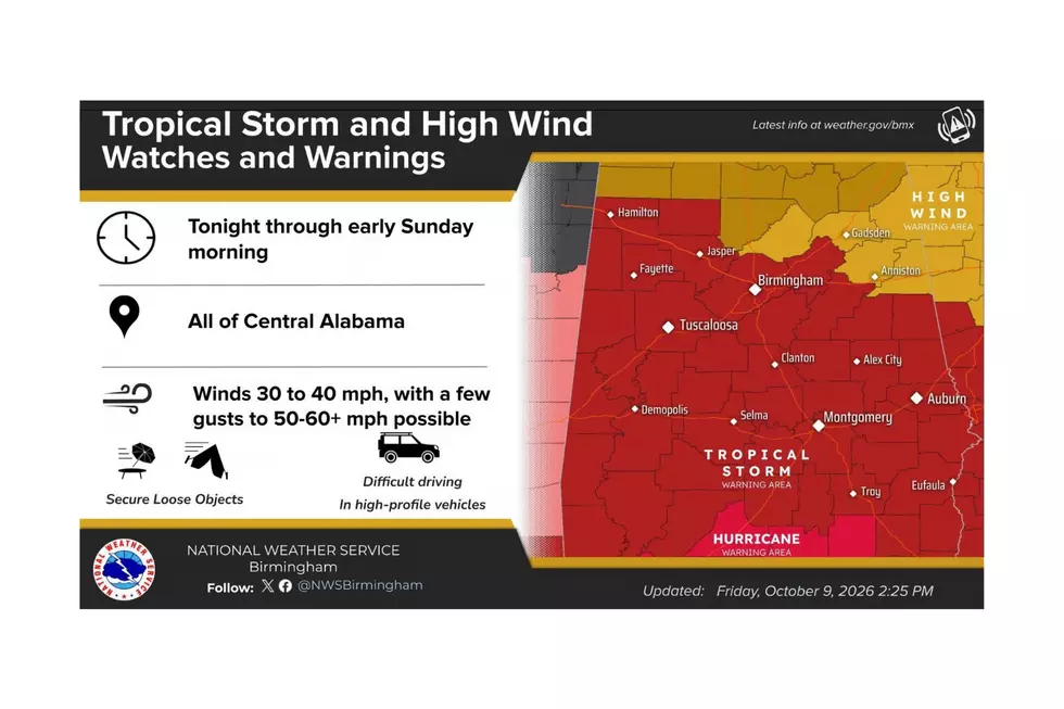
Hurricane Isaias Turns Northward: West Alabama Braces for Possible Impacts
According to the National Hurricane Center, “ISAIAS MAKES LANDFALL NEAR DESTIN, FLORIDA. LIFE-THREATENING STORM SURGE IMPACTING THE GULF COAST AS DANGEROUS HURRICANE CONDITIONS AND FLASH FLOODING SPREAD INLAND"
Hurricane Isaias strengthened into a Category 3 this morning and remains a strong hurricane.
It is expected to bring widespread power outages, airport delays, and hazardous road conditions along its path. It also brings heavy rain, strong winds, flash flooding, and, for some, a potential tornado threat.
Isaias Stats as of Friday, October 9, at p.m.
- The system is moving North and is expected to continue on a northward track.
- The speed of the system is 19 mph
- Maximum sustained wind speed is 105 mph
- Minimum pressure is 959 mb
- Seas near the center are up to 33 ft.

What Happens After Landfall?
“A northward motion is expected to continue through Saturday, bringing Isaias's center through Alabama, followed by a northeastward trajectory across Tennessee and the central Appalachians on Sunday,” said the National Hurricane Center.
Because Isaias is expected to move quickly, strong hurricane-force winds could reach well inland.
The National Weather Service in Birmingham said they have high confidence in the track and intensity as the system approaches the coast.
Weather Alerts for West Alabama
- Tropical Storm Warning
- Flood Watch
- Level 2 out of 5 for severe weather impacts a southern portion of Perry County
Potential Impacts in West Alabama
- Winds 30 to 40 mph with gusts to 50 to 60+ mph possible
- Damaging winds are expected that may cause downed trees and power outages
- Heavy Rainfall
- Rainfall that could lead to flash flooding
- West Alabama is in the Slight Risk zone for excessive rainfall leading to flash flooding
“Wind is the BIG issue,” said James Spann, Alabama Weather Network Chief Meteorologist. “Winds at hurricane force on the coast. Due to the accelerating forward speed and expanding wind field, most all of inland Alabama could see gusts to 50/60 mph overnight tonight. This will likely create major power outages and considerable tree damage.”
Timing
West Alabama is most likely to feel tropical storm-force winds late this evening and overnight Saturday into early Saturday morning.
Townsquare Media Weather Center
The Townsquare Media Weather Center will remain on duty and provide coverage until Isaias moves out of our coverage area. In the meantime, please make sure your cell phones, computers, iPads, and tablets are fully charged so you can stay connected and informed throughout the storm.
Stay safe and weather-aware.
Mary K. – Weather Forecaster
West Alabama County-by-County Alert Guide
Bibb
TROPICAL STORM WARNING IN EFFECT
Flood Watch from Friday, October 9 at 7 p.m. until Sunday, October 11 at 7 a.m.
Fayette
TROPICAL STORM WARNING IN EFFECT
Flood Watch from Friday, October 9 at 7 p.m. until Sunday, October 11 at 7 a.m.
Greene
TROPICAL STORM WARNING IN EFFECT
Flood Watch from Friday, October 9 at 7 p.m. until Sunday, October 11 at 7 a.m.
Hale
TROPICAL STORM WARNING IN EFFECT
Flood Watch from Friday, October 9 at 7 p.m. until Sunday, October 11 at 7 a.m.
Lamar
TROPICAL STORM WARNING IN EFFECT
Flood Watch from Friday, October 9 at 7 p.m. until Sunday, October 11 at 7 a.m.
Perry
TROPICAL STORM WARNING IN EFFECT
Slight risk (Level 2 of 5) for tornadoes in the southern portion of Perry County.
Flood Watch from Friday, October 9 at 7 p.m. until Sunday, October 11 at 7 a.m.
Pickens
TROPICAL STORM WARNING IN EFFECT
Flood Watch from Friday, October 9 at 7 p.m. until Sunday, October 11 at 7 a.m.
Sumter
TROPICAL STORM WARNING IN EFFECT
Flood Watch from Friday, October 9 at 7 p.m. until Sunday, October 11 at 7 a.m.
Tuscaloosa
TROPICAL STORM WARNING IN EFFECT
Flood Watch from Friday, October 9 at 7 p.m. until Sunday, October 11 at 7 a.m.
Walker
TROPICAL STORM WARNING IN EFFECT
Flood Watch from Friday, October 9 at 7 p.m. until Sunday, October 11 at 7 a.m.
KEEP READING: Get answers to 51 of the most frequently asked weather questions...
LOOK: The most extreme temperatures in the history of every state
Gallery Credit: Anuradha Varanasi
LOOK: The most expensive weather and climate disasters in recent decades
Gallery Credit: KATELYN LEBOFF
More From 92.9 WTUG