
Alert: Alabama Braces for Daytime Severe Weather Threat
Severe weather is expected on Friday, January 12, in the Townsquare Media coverage area and a significant portion of Alabama. The active weather that should enter Alabama from the west is part of a larger weather situation.
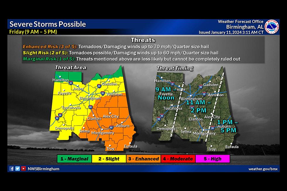
Timing
The current timing of the severe weather impacts will be from 9 a.m. until 5 p.m. This will be from 9 a.m. to Noon (for the majority of West Alabama) and then 2 p.m. for some counties like Bibb and Perry. However, I would like to stress not to get too caught up in timing because as the system tracks closer to Alabama, there could be a shift in timing.
West Alabama County-by-County Timing Guide
Bibb - from 11 a.m. until 2 p.m.
Fayette – from 9 a.m. until Noon
Greene – from 9 a.m. until Noon
Hale – from 9 a.m. until Noon
Lamar – from 9 a.m. until Noon
Perry – from 11 a.m. until 2 p.m.
Pickens – from 9 a.m. until Noon
Sumter – from 9 a.m. until Noon
Tuscaloosa – from 9 a.m. until Noon
Walker – from 9 a.m. until Noon
Risk Areas
The Storm Prediction Center has the state of Alabama divided into 3 different risk areas.
Level 3 - "Enhanced Risk"
Level 2 - Slight Risk"
Level 1 - "Marginal Risk"

James Spann, ABC 33/40, and Townsquare Media Tuscaloosa Chief Meteorologist said that “the big question concerns the northward extent of unstable air; for now, we believe the highest risk of severe storms will be along and south of I-20, over the southern 2/3 of Alabama. Here are the key messages for the event tomorrow.”
Main Threats
You should be prepared for damaging winds up to 70 mph, hail up to quarter-size, and some tornadoes. Those in the “enhanced risk” area could see an EF-2 tornado.
In addition, there is a wind advisory for portions of Alabama. Non-thunderstorm-related winds could occur with “sustained winds of 20-30 mph and gusts up to 50 mph,” said the National Weather Service in Birmingham.
READ MORE: Wind Advisory: Gusts up to 50 Mph Possible on Friday in Alabama
Does This System Only Impact Alabama?
The short answer is no.
The Weather Channel said that “damaging straight-line winds and a tornado threat will accompany those storms, especially from central and southern parts of Mississippi and Alabama eastward into much of Georgia, northern Florida, and the Carolinas. That includes the risk of a few strong tornadoes (EF2 or greater), particularly if supercell thunderstorms form.”
The Townsquare Media Weather Center team will be on standby for Friday’s weather events. We will provide nonstop weather coverage whenever a tornado warning is issued for a county under our coverage area.
Townsquare Media Radio Stations
Praise 93.3
92.9 WTUG
95.3 The Bear
METV 97.5
Catfish 100.1
Tide 100.9
ALT 101.7
105.1 The Block
Amazing and Intriguing Weather Folklore
Signs of a Bad Winter According to Weather Folklore
Gallery Credit: Mary K
Understanding Various Types of Winter Weather Alerts in Alabama
Gallery Credit: Mary K