Peak Hurricane Season Info
Peak Hurricane Season Info

Here is some insight on the peak of hurricane season which runs from late August through late September. However, the Atlantic hurricane season is from June 1st until November 30th.
Growing up in South Florida, I was always drawn to the study of hurricanes. Every year I would pick up my hurricane tracking map from the local TV station and plotted every tropical activity. My first experience was in August of 1979 which was Hurricane David.
According to the University Corporation for Atmospheric Research, here is the information on how hurricanes grow and form.
- Hurricanes take energy from the warm ocean water to become stronger. While a hurricane is over warm water, it will continue to grow.
- Because of low pressure at its center, winds flow towards the center of the storm, and air is forced upward. High in the atmosphere, winds flow away from the storm, which allows more air from below to rise.
- The air that rises needs to be warm and moist so that it forms the clouds of the storm. Warm, moist air is found above warm, tropical ocean waters.
- A hurricane also needs the winds outside the storm to be light. These winds steer the storm, but are not strong enough to disrupt it.
Also, with these storms, they grow into various intensity levels before becoming a hurricane. According to the National Weather Service, they are:
Tropical disturbance: originating in the tropics or subtropics, having a non-frontal migratory character and maintaining its identity for 24 hours or longer
Tropical depression: maximum sustained surface wind of 38 mph or less.
Tropical storm: maximum sustained surface wind of 39 mph to 74 mph.
Hurricane: maximum sustained surface wind of 74 mph and more.
Hurricanes are measure by their strength and placed into five categories by using the Saffir Simpson Hurricane Wind Scale. Here are the details according to CNN weather:
Category 1: Winds 74 to 95 mph (Minor damage)
Category 2: Winds 96 to 110 mph (Extensive damage -- Can uproot trees and break windows)
Category 3: Winds 111 to 129 mph (Devastating -- Can break windows and doors)
Category 4: Winds 130 to 156 mph (Catastrophic damage -- Can tear off roofs)
Category 5: Winds 157 mph or higher (The absolute worst and can level houses and destroy buildings)
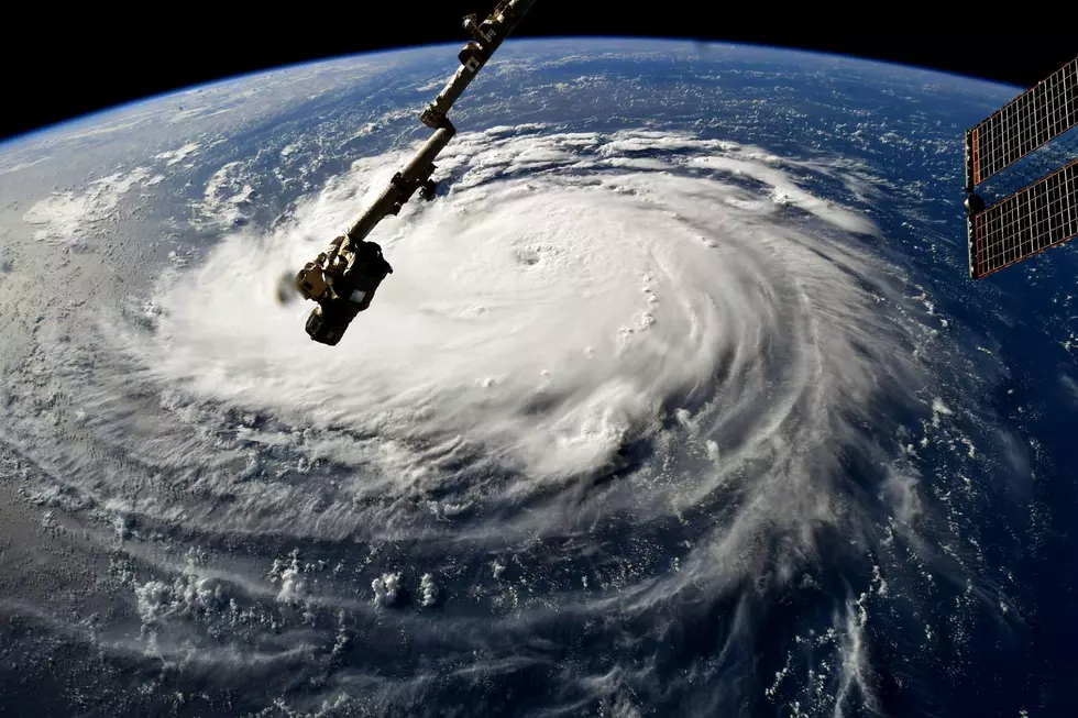
According to the National Aeronautics and Space Administration, here are the various parts of a hurricane.
“Eye: The eye is the "hole" at the center of the storm. Winds are light in this area. Skies are partly cloudy, and sometimes even clear.
Eye wall: The eye wall is a ring of thunderstorms. These storms swirl around the eye. The wall is where winds are strongest and rain is heaviest.
Rain bands: Bands of clouds and rain go far out from a hurricane's eye wall. These bands stretch for hundreds of miles. They contain thunderstorms and sometimes tornadoes.”
Some weather vocabulary can be confusing at times. During Hurricane season, it is important to be aware of these terms so you can be weather and hurricane aware. Quartz has offered some great information on hurricane terms.
The American GFS model is the Global Forecast System storm model run by the National Weather Service that predicts a storm’s projected path.
The best track is a smoothed representation of a storm’s location and intensity over its lifetime. The best track contains the storm system’s latitude, longitude, maximum sustained surface winds, and minimum sea-level pressure at six-hour intervals, based on a post-storm assessment of all available data.
The European model is considered by meteorologists to be the most accurate model for predicting hurricanes in the mid-latitude
A storm surge is the rise in sea levels following a hurricane or major storm, where the height is the difference between the observed sea level and the level the water would be without a cyclone.
A hurricane warning is an announcement that hurricane conditions (sustained winds of 74 mph or higher) are expected somewhere within the specified area in association with a tropical storm.
A hurricane watch is an announcement that hurricane conditions (sustained winds of 74 mph or higher) are possible within the specified area in association with a tropical storm.
(Source) For more from the University Corporation for Atmospheric Research, click here. For more from the National Weather Service, click here. For more from CNN Weather, click here. For more from the National Aeronautics and Space Administration, click here. For more from Quartz, click here
Hurricane Terms You Need to Know
More From 92.9 WTUG