
Active Weather Day Ahead Includes Threats of Flooding, Tornadoes
The Townsquare Media Tuscaloosa weather center has been closely monitoring a storm system that will move into our area today and through the evening hours. The main concerns are the potential for flooding, damaging winds, and tornadoes.
As a reminder, when any of the counties under our listening coverage area experience a “Tornado Warning” we will bring you nonstop weather coverage until that warning has expired or been canceled.
Townsquare Media Coverage Areas
Bibb
Fayette
Greene
Hale
Lamar
Perry
Pickens
Sumter
Tuscaloosa
Walker
Townsquare Media Radio Stations
Praise 93.3
92.9 WTUG
95.3 The Bear
METV 97.5
Catfish 100.1
Tide 100.9
ALT 101.7
105.1 The Block
There are two chief areas of concern: The likelihood of flooding and the potential for severe storms that include damaging winds and tornadoes.

Flooding Possibility
James Spann, ABC 33/40, and Townsquare Media Tuscaloosa Chief Meteorologist said that the “main threat of flooding today is over the northern half of the state... a flash flood watch is in effect north of a line from Butler to Marion to Clanton to Anniston... amounts of 2 inches will be common here, with isolated totals to 3 inches."

Severe Thunderstorm Threat
“The core threat of severe thunderstorms today will be over the southern half of Alabama, where the air will be somewhat unstable,” said Spann.
Winds
Wind gusts could get up to 30 miles per hour not related to thunderstorms.
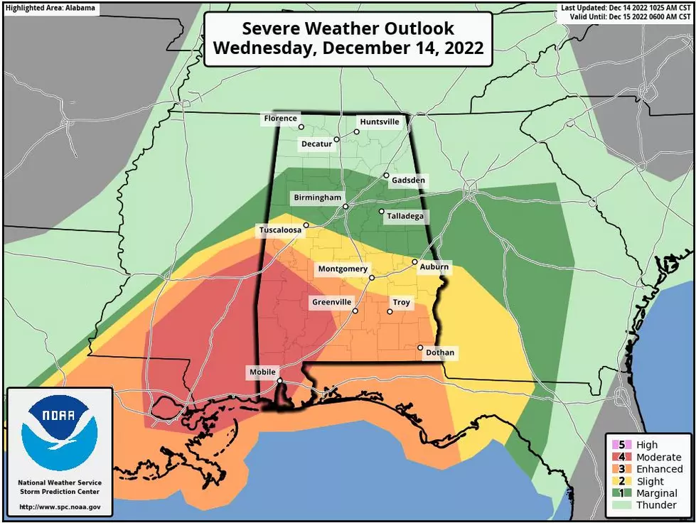
The Storm Prediction Center Risk Levels
Level 3 out of 5 - "Enhanced Risk"
Areas south and west of a line from Demopolis to Greenville to Geneva.
Level 2 out of 5 - "Slight Risk"
Extends as far north as Tuscaloosa, Jemison, and Opelika.
Level 1 out of 5 - "Marginal risk"
Runs up to Jasper, Birmingham, and Anniston, but the chance of severe storms there is low since the air will be cool and stable said Spann.
SPC upgrades Southwest Alabama to a “moderate risk” (level 4/5) this afternoon and early tonight… tornadoes, including the possibility of strong and long-track tornadoes, are the primary concern," said Spann.

National Weather Service in Birmingham Highlights
Where:
Severe: Southwest half of Central Alabama
Flooding: Northwest half of Central Alabama
When:
Severe: Noon today through 2 am Thursday morning
Flooding: Now through midnight Thursday
Threats:
Flash flooding and river flooding
Damaging winds
Tornadoes
(Source) For more from the National Weather Service Birmingham, click here. Click here to follow the Facebook Page for James Spann.
Top Stories from the Tuscaloosa Thread (12/5 - 12/12)
Gallery Credit: (Stephen Dethrage | Tuscaloosa Thread)
KEEP READING: What to do after a tornado strikes
TIPS: Here's how you can prepare for power outages
More From 92.9 WTUG


