
Enhanced Severe Weather, Tornado Threat for Portions of Alabama
We are starting 2023 with the risk of severe weather for nearly all of Alabama. It is not odd for our area to have severe weather in January because our season runs from November through May.
We encourage you to stay aware, be prepared, understand what county you live in and what section of that county, know your safe place at home, work, and school, and have a way to receive weather information.

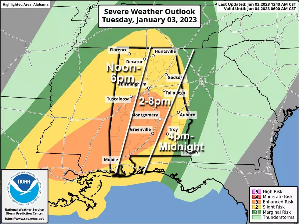
Risk Levels and Possible Impacted Areas
The Storm Prediction Center has upgraded some portions of our coverage area to an "enhanced risk" which is a level 3 out of 5 for severe thunderstorms this includes Central and Southwest Alabama. Almost the remainder of the state is under a “slight risk” which is a level 2 out of 5.
Timing
James Spann, ABC 33/40, and Townsquare Media Tuscaloosa Chief Meteorologist said that “the window for strong to severe thunderstorms will open around 12 noon over the western third of the state tomorrow, with the risk shifting eastward through the afternoon and evening hours. Thunderstorms that form will be capable of producing strong winds, hail, and a few tornadoes. A strong tornado (EF-2 or higher) is possible in the enhanced risk area.”

Storm Prediction Center Tornado Outlook
According to the Storm Prediction Center in the below graphic the “probability of a tornado within 25 miles of a point is 10 to 14%.”

National Weather Service in Birmingham Highlights
Where:
All of Central Alabama
When:
Late Tuesday morning through late Tuesday night
Threats:
Tornadoes possible
Damaging wind gusts up to 60 mph
Quarter size hail
Localized flooding (Tuesday into Wednesday morning)
(Source) Click here to follow the Facebook Page for James Spann. For more from the National Weather Service Birmingham, click here. Click here for more from the Storm Prediction Center.
LOOK: What major laws were passed the year you were born?
Gallery Credit: Katelyn Leboff
LOOK: Food history from the year you were born
Gallery Credit: Joni Sweet
LOOK: Things from the year you were born that don't exist anymore
Gallery Credit: Stacey Marcus
More From 92.9 WTUG


