
Late Week Threat: Risk of Damaging Winds, Tornadoes in Alabama
I don’t know about you but nothing says spring like waking up to 34 degrees.
Hopefully soon our area will be able to enjoy springtime weather. However, my mother always warned me of an April freeze.
Currently, we are closely monitoring the potential for severe weather late this week with concerns of damaging winds and possible tornadoes.

I would like to stress the importance of checking weather information because as conditions change so will the forecast. The threat timing and threat levels could be adjusted.
James Spann, ABC 33/40, and Townsquare Media Tuscaloosa Chief Meteorologist said that during the day on Friday it will be "warm and breezy with a high back in the low 80s. Then a cold front will push an organized band of showers and thunderstorms into the state Friday into early Saturday morning. SPC maintains a risk of severe thunderstorms for Northwest Alabama in their "Day 4" outlook.”
Timing
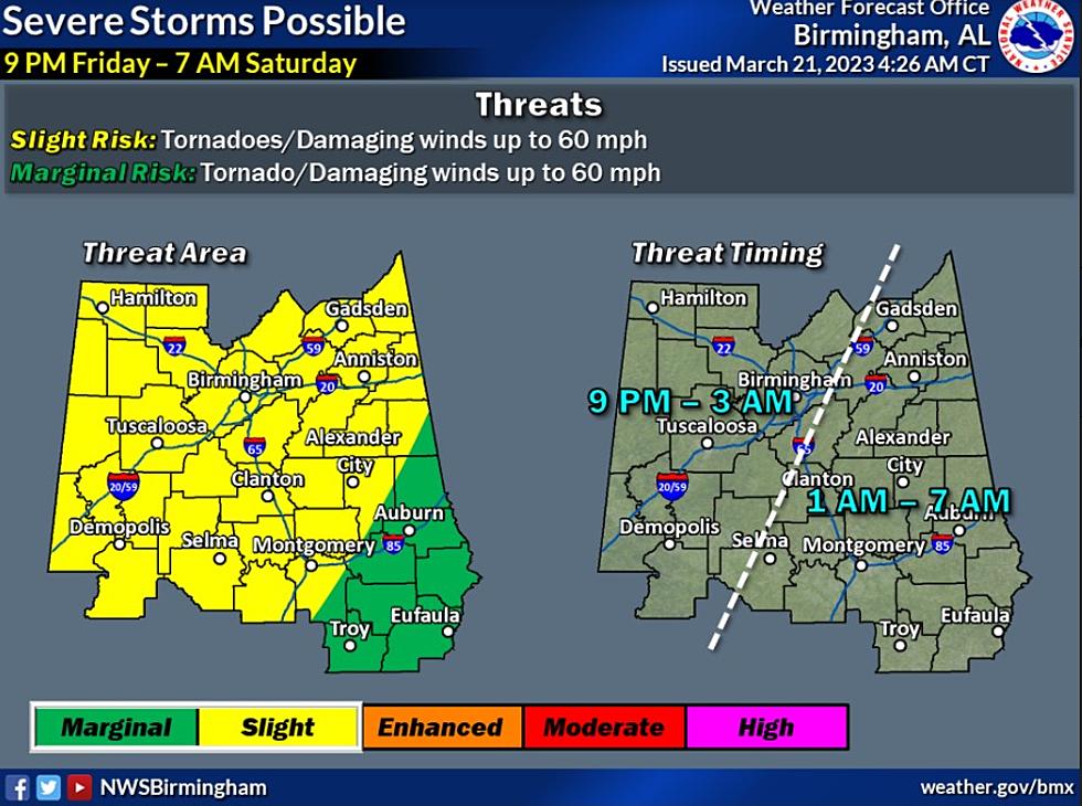
As of right now, the overall threat timeframe according to the National Weather Service in Birmingham is from "Friday at 9:00 p.m. until Saturday at 7:00 a.m. However, our coverage area is in the window between Friday at 9:00 p.m. and Saturday at 3:00 a.m."

Threats
The outlook is calling for threats like damaging winds up to 60 miles per hour and the possibility of a few tornadoes.
We will be sure to keep you updated on this incoming active weather system.
(Source) For more from the National Weather Service Birmingham, click here. Click here to follow the Facebook Page for James Spann.
LOOK: Here are the 50 best beach towns in America
Gallery Credit: Keri Wiginton
READ ON: See the States Where People Live the Longest
Gallery Credit: Hannah Lang
LOOK: Here are the best small towns to live in across America
More From 92.9 WTUG


