Possible Damaging Winds, Hail, Flooding in Portions of Alabama
Saturday Outlook
Saturday morning you can expect some showers and storms across Central Alabama. Then this afternoon into the evening hours thunderstorms could develop over the southern portion of the Yellowhammer State.

Risk Areas
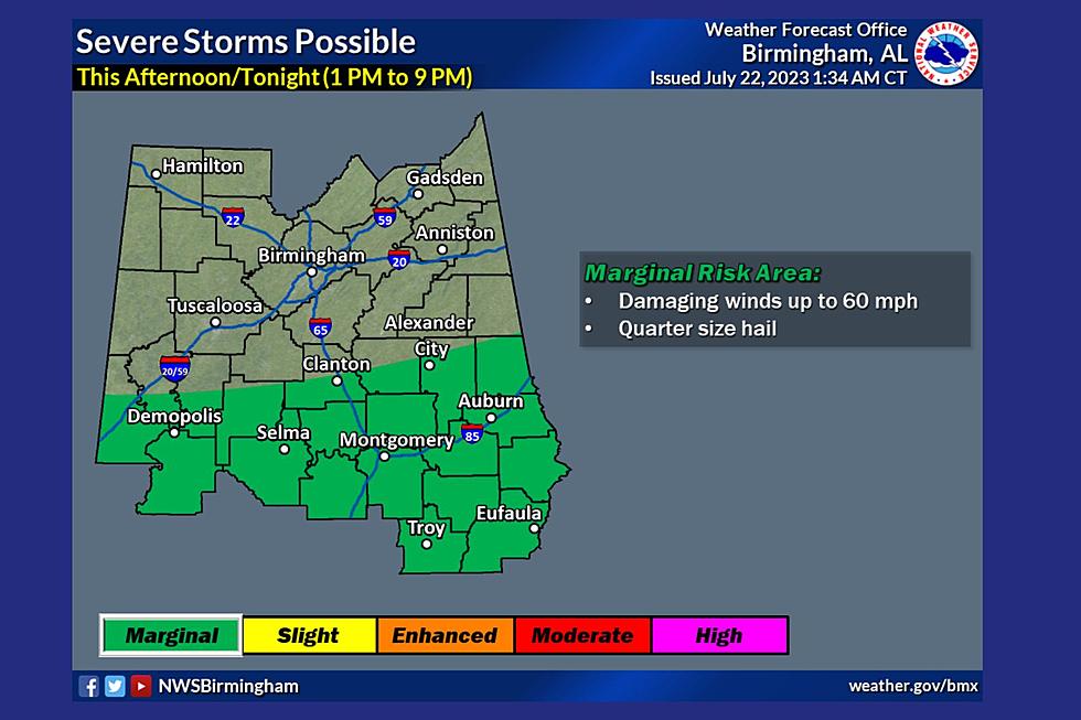
The Storm Prediction Center (SPC) has portions of the Townsquare Media Coverage area under a “marginal risk” for thunderstorms which is a level 1 out of 5. This includes portions of Sumter, Greene, Hale, and Perry counties.

Timing
According to the National Weather Service in Birmingham, the window of possible severe weather is from “1 p.m. until 9 p.m.” The timing could change due to incoming weather conditions. We will continue to monitor.
Possible Threats
The potential threats are damaging winds up to 60 mph and quarter-size hail. Also, “storms may move over the same areas, and with high rainfall rates expected, localized flooding may be a concern,” said the National Weather Service in Birmingham.
Sunday Outlook
James Spann, ABC 33/40, and Townsquare Media Tuscaloosa Chief Meteorologist said that “most of the state will be dry tomorrow with a mostly sunny sky; scattered storms will be confined to the far southern counties. The high tomorrow afternoon will be in the 88–92-degree range.”
(Source) Click here to follow the SPC. Click here to follow the National Weather Service in Birmingham's Facebook page. Click here to follow the James Spann Facebook page.
Unique Getaway in Mississippi: Stay in a Silo Farmhouse
Gallery Credit: Mary K
Step Inside The Grimsley House Airbnb in Fayette, Alabama
Gallery Credit: Mary K
Alabama’s Most Luxurious Airbnb is Like Staying on a Movie Set
Gallery Credit: Mary K
This Smith Lake Alabama Airbnb is a 3 Level Showpiece
Gallery Credit: Mary K
THIS is the Most Expensive Airbnb in Alabama, See it for Yourself
Gallery Credit: Mary K
More From 92.9 WTUG