Tuesday Morning Update On Flood Potential & Potential For Severe Weather
Weather Heads Up
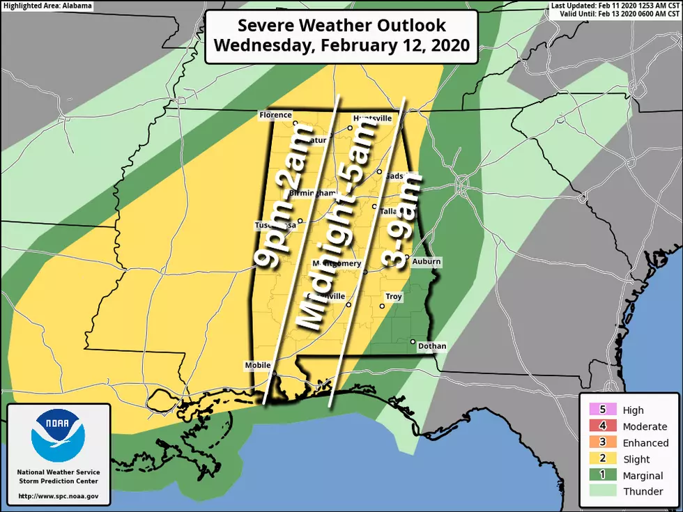
Big Weather Updates for you, I wanted to give you now a heads up about the possibility of severe weather for our area starting Wednesday, February 12th in the evening going through the overnight hours. All of our listening areas are under a “slight risk” from the National Weather Service. Right now, the main concerns are the possibility of a tornado, hail, and damaging winds.

For road closures, please be sure to check the Tuscaloosa County Public Works Website with an interactive map. We strongly encourage you to obey all barricades and do not attempt to drive through flooded areas.
Today, our areas will be dealing with a 90% chance of precipitation. I am very concerned because we have already had a significant amount of rain so far. The ground is already saturated and this leads to the potential of flooding and flash flooding. Currently, we are dealing with the following from the National Weather Service
A Flash Flood Warning in effect for now until 915 am for Southern Tuscaloosa County in West Alabama.
A Flash Flood Watch in effect now until Tuesday, February 11th at 6 pm. This affects portions of central Alabama, east-central Alabama, northeast Alabama, and west-central Alabama.
A Flood Warning Continues for:
Locust Fort At Sayre
Black Warrior River At Holt Lock and Dam
Black Warrior River At Selden Lock and Dam
Black Warrior River At Oliver Lock and Dam affecting Greene, Hale, Marengo, Sumter, and Tuscaloosa Counties.
https://forecast.weather.gov/showsigwx.php?warnzone=ALZ023&warncounty=ALC125&firewxzone=ALZ023&local_place1=Tuscaloosa%20AL&product1=Flood+Warning&lat=33.2377&lon=-87.541#.XkKtAGhKiM8
More From 92.9 WTUG