
Portions of Alabama Prepare for Damaging Winds, Flooding, Heat
EXPIRED WEATHER INFORMATION
Currently, the National Weather Service has Bibb, Fayette, Lamar, Pickens, Tuscaloosa, and Walker counties under a “Heat Advisory” until Thursday at 9 p.m.
There is a “Heat Advisory” that remains in effect from the National Weather Service for Greene, Hale, Perry, and Sumter counties until Friday at 9 p.m. There is the possibility of heat index values reaching 110 degrees.
The National Weather Service has issued a “Severe Thunderstorm Watch” until 8 p.m. for Hale, Perry, Greene, and Pickens County.
5:30 - The National Weather Service in Birmingham has issued a
* Severe Thunderstorm Warning for...
Southern Pickens County in west central Alabama...
* Until 600 PM CDT.
* At 530 PM CDT, severe thunderstorms were located along a line
extending from near Deerbrook to Union, moving south at 25 mph.
HAZARD...60 mph wind gusts.
SOURCE...Radar indicated.
IMPACT...Expect damage to roofs, siding, and trees.
* Locations impacted include...
Aliceville, Pickensville, Memphis, McMullen, Garden, Benevola,
Johnston Lake, Bevill Lock And Dam, Gainesville Lake Campground,
Cochrane and George Downer Airport.
PRECAUTIONARY/PREPAREDNESS ACTIONS...
For your protection move to an interior room on the lowest floor of a
building.
HAIL THREAT...RADAR INDICATED
MAX HAIL SIZE...<.75 IN
WIND THREAT...RADAR INDICATED
MAX WIND GUST...60 MPH
5:20 - SEVERE THUNDERSTORM WATCH 581 REMAINS VALID UNTIL 8 PM CDT THIS EVENING FOR THE FOLLOWING AREAS IN ALABAMA THIS WATCH INCLUDES 14 COUNTIES IN CENTRAL ALABAMA:
AUTAUGA, BULLOCK, CHAMBERS, COOSA, ELMORE, GREENE,
HALE, LEE, MACON, MONTGOMERY, PERRY, PICKENS, RUSSELL AND TALLAPOOSA
THIS INCLUDES THE CITIES OF ALEXANDER CITY, ALICEVILLE, AUBURN,
CARROLLTON, EUTAW, GREENSBORO, LANETT, MARION, MILLBROOK,
MONTGOMERY, MOUNDVILLE, OPELIKA, PHENIX CITY, PRATTVILLE,
ROCKFORD, TUSKEGEE, UNION SPRINGS, UNIONTOWN, VALLEY,
AND WETUMPKA.
5:20 - THE NATIONAL WEATHER SERVICE HAS CANCELLED SEVERE THUNDERSTORM WATCH 581 FOR THE FOLLOWING AREAS
IN ALABAMA THIS CANCELS 4 COUNTIES IN CENTRAL ALABAMA:
BIBB, CHILTON, RANDOLPH, TUSCALOOSA
THIS INCLUDES THE CITIES OF BRENT, CENTREVILLE, CLANTON, ROANOKE,
AND TUSCALOOSA.
5:02 - The National Weather Service in Birmingham has issued a
* Severe Thunderstorm Warning for...
Greene County in west central Alabama...
Northwestern Sumter County in west central Alabama...
* Until 600 PM CDT.
* At 500 PM CDT, severe thunderstorms were located along a line
extending from near Deerbrook to near Jena, moving southeast at 30
mph.
HAZARD...60 mph wind gusts.
SOURCE...Radar indicated.
IMPACT...Expect damage to roofs, siding, and trees.
* Locations impacted include...
Eutaw, Boligee, Union, Gainesville, New West Greene, Mantua, Panola, Allison, Walden Quarters, West Greene, Knoxville, Thornhill, Jena, Geiger, Snoddy, Warsaw, New Mount Hebron, Eutaw Municipal Airport, Clinton and Pleasant Ridge.
PRECAUTIONARY/PREPAREDNESS ACTIONS...
For your protection move to an interior room on the lowest floor of a
building.
HAIL THREAT...RADAR INDICATED
MAX HAIL SIZE...<.75 IN
WIND THREAT...RADAR INDICATED
MAX WIND GUST...60 MPH
4:54 - THE SEVERE THUNDERSTORM WARNING FOR SOUTH CENTRAL TUSCALOOSA...NORTHEASTERN HALE AND BIBB COUNTIES IS CANCELLED...
The storms which prompted the warning have moved out of the warned
area. Therefore, the warning has been cancelled.
A Severe Thunderstorm Watch remains in effect until 800 PM CDT for
central and east central Alabama.
4:52 - A SEVERE THUNDERSTORM WARNING REMAINS IN EFFECT UNTIL 530 PM CDT FOR PICKENS COUNTY...
At 451 PM CDT, severe thunderstorms were located along a line
extending from near Bigbee Valley to near Jena, moving south at 25
mph.
HAZARD...60 mph wind gusts.
SOURCE...Radar indicated.
IMPACT...Expect damage to roofs, siding, and trees.
Locations impacted include...
Aliceville, Gordo, Carrollton, Pickensville, Memphis, McMullen,
Garden, Benevola, Johnston Lake, Bevill Lock And Dam, Gainesville
Lake Campground, Dillburg, George Downer Airport, Owens, Kirk,
Pioneer, Cochrane and Macedonia.
4:46 - SEVERE THUNDERSTORM WATCH 581 REMAINS VALID UNTIL 8 PM CDT THIS EVENING FOR THE FOLLOWING AREAS IN ALABAMA THIS WATCH INCLUDES 16 COUNTIES IN CENTRAL ALABAMA:
AUTAUGA, BIBB, CHAMBERS, CHILTON, COOSA, ELMORE, GREENE, HALE, LEE, MACON, PERRY, PICKENS, RANDOLPH, RUSSELL, TALLAPOOSA AND TUSCALOOSA
THIS INCLUDES THE CITIES OF ALEXANDER CITY, ALICEVILLE, AUBURN,
BRENT, CARROLLTON, CENTREVILLE, CLANTON, EUTAW, GREENSBORO,
LANETT, MARION, MILLBROOK, MOUNDVILLE, OPELIKA, PHENIX CITY,
PRATTVILLE, ROANOKE, ROCKFORD, TUSCALOOSA, TUSKEGEE, UNIONTOWN,
VALLEY, AND WETUMPKA.
4:37 - A SEVERE THUNDERSTORM WARNING REMAINS IN EFFECT UNTIL 500 PM CDT FOR CHILTON...SOUTH CENTRAL TUSCALOOSA...NORTHEASTERN HALE...BIBB...NORTHERN TALLAPOOSA AND COOSA COUNTIES...
At 437 PM CDT, severe thunderstorms were located along a line extending from near Moundville to near Clanton to near Goldville, moving southeast at 25 mph.
HAZARD...60 mph wind gusts.
SOURCE...Radar indicated.
IMPACT...Expect damage to roofs, siding, and trees.
Locations impacted include...
Alexander City, Clanton, Brent, Dadeville, Centreville, Jemison, Goodwater, Rockford, Kellyton, Equality, Weogufka, Thorsby, Jacksons' Gap, New Site, Maplesville, Goldville, Dollar, Bradford, Gap Of The Mountain and Bentleyville.
PRECAUTIONARY/PREPAREDNESS ACTIONS...
For your protection move to an interior room on the lowest floor of a
building.
HAIL THREAT...RADAR INDICATED
MAX HAIL SIZE...<.75 IN
WIND THREAT...RADAR INDICATED
MAX WIND GUST...60 MPH
4:35 - Severe Thunderstorm Warning
National Weather Service Birmingham AL
435 PM CDT Thu Aug 3 2023
The National Weather Service in Birmingham has issued a
* Severe Thunderstorm Warning for...
Pickens County in west central Alabama...
* Until 530 PM CDT.
* At 435 PM CDT, severe thunderstorms were located along a line
extending from 7 miles south of Columbus to near Gordo, moving
south at 35 mph.
HAZARD...60 mph wind gusts.
SOURCE...Radar indicated.
IMPACT...Expect damage to roofs, siding, and trees.
* Locations impacted include...
Aliceville, Gordo, Reform, Carrollton, Pickensville, Ethelsville, Memphis, McMullen, Garden, Benevola, Johnston Lake, Bevill Lock And Dam, Gainesville Lake Campground, Dillburg, North Pickens Airport, McShan, George Downer Airport, Owens, Kirk and Pioneer.
PRECAUTIONARY/PREPAREDNESS ACTIONS...
For your protection move to an interior room on the lowest floor of a
building.
HAIL THREAT...RADAR INDICATED
MAX HAIL SIZE...<.75 IN
WIND THREAT...RADAR INDICATED
MAX WIND GUST...60 MPH
4:20 - A SEVERE THUNDERSTORM WARNING REMAINS IN EFFECT UNTIL 500 PM CDT FOR CHILTON...SOUTH CENTRAL TALLADEGA...SOUTHEASTERN TUSCALOOSA...SOUTHERN SHELBY...NORTHEASTERN HALE...BIBB...NORTHERN TALLAPOOSA...
COOSA AND SOUTHWESTERN CLAY COUNTIES...
At 420 PM CDT, severe thunderstorms were located along a line extending from near Shelton State Community College to near Gap Of The Mountain to 8 miles northwest of Goldville, moving southeast at 30 mph.
HAZARD...60 mph wind gusts.
SOURCE...Radar indicated.
IMPACT...Expect damage to roofs, siding, and trees.
Locations impacted include...
Southern Tuscaloosa, Alexander City, Sylacauga, Calera, Clanton, Montevallo, Brent, Dadeville, Centreville, Jemison, Goodwater, Rockford, Kellyton, Talladega Springs, Weogufka, Stewartville, Equality, Thorsby, Coaling and Vance.
PRECAUTIONARY/PREPAREDNESS ACTIONS...
For your protection move to an interior room on the lowest floor of a
building.
HAIL THREAT...RADAR INDICATED
MAX HAIL SIZE...<.75 IN
WIND THREAT...RADAR INDICATED
MAX WIND GUST...60 MPH
4:19 - THE NATIONAL WEATHER SERVICE HAS CANCELLED SEVERE THUNDERSTORM WATCH 581 FOR THE FOLLOWING AREAS IN ALABAMA THIS CANCELS 7 COUNTIES IN CENTRAL ALABAMA:
CALHOUN, CLEBURNE, FAYETTE, JEFFERSON, LAMAR, ST. CLAIR, WALKER
THIS INCLUDES THE CITIES OF ANNISTON, BIRMINGHAM, FAYETTE,
HEFLIN, HOOVER, JACKSONVILLE, JASPER, MOODY, PELL CITY,
SULLIGENT, AND VERNON.
4:19 - SEVERE THUNDERSTORM WATCH 581 REMAINS VALID UNTIL 8 PM CDT THIS EVENING FOR THE FOLLOWING AREAS IN ALABAMA THIS WATCH INCLUDES 19 COUNTIES IN CENTRAL ALABAMA:
AUTAUGA, BIBB, CHAMBERS, CHILTON, CLAY, COOSA, ELMORE, GREENE, HALE, LEE, MACON, PERRY, PICKENS, RANDOLPH, RUSSELL, SHELBY, TALLADEGA, TALLAPOOSA AND TUSCALOOSA
THIS INCLUDES THE CITIES OF ALABASTER, ALEXANDER CITY, ALICEVILLE, ASHLAND, AUBURN, BRENT, CARROLLTON, CENTREVILLE, CLANTON, COLUMBIANA, EUTAW, GREENSBORO, LANETT, LINEVILLE, MARION, MILLBROOK, MOUNDVILLE, OPELIKA, PELHAM, PHENIX CITY, PRATTVILLE, ROANOKE, ROCKFORD, SYLACAUGA, TALLADEGA, TUSCALOOSA, TUSKEGEE, UNIONTOWN, VALLEY, AND WETUMPKA.
4:15 - A SEVERE THUNDERSTORM WARNING REMAINS IN EFFECT UNTIL 500 PM CDT FOR CHILTON...SOUTHWESTERN TALLADEGA...SOUTHERN TUSCALOOSA...SOUTHERN SHELBY...NORTHEASTERN HALE...BIBB...NORTHERN TALLAPOOSA...COOSA AND
SOUTHWESTERN CLAY COUNTIES...
At 414 PM CDT, severe thunderstorms were located along a line
extending from 6 miles southwest of Tuscaloosa Regional Airport to
near Jemison to near Goodwater, moving southeast at 30 mph.
HAZARD...60 mph wind gusts.
SOURCE...Radar indicated.
IMPACT...Expect damage to roofs, siding, and trees.
Locations impacted include...
Tuscaloosa, Northport, Alexander City, Sylacauga, Calera, Clanton, Montevallo, Brent, Columbiana, Dadeville, Centreville, Jemison, Wilsonville, Goodwater, Rockford, Kellyton, Talladega Springs, Weogufka, Stewartville and Holt.
PRECAUTIONARY/PREPAREDNESS ACTIONS...
For your protection move to an interior room on the lowest floor of a
building.
HAIL THREAT...RADAR INDICATED
MAX HAIL SIZE...<.75 IN
WIND THREAT...RADAR INDICATED
MAX WIND GUST...60 MPH
3:54 - A SEVERE THUNDERSTORM WARNING REMAINS IN EFFECT UNTIL 415 PM CDT FOR SOUTHERN TALLADEGA...CENTRAL TUSCALOOSA...SHELBY...NORTHEASTERN
BIBB AND SOUTH CENTRAL JEFFERSON COUNTIES...
At 353 PM CDT, severe thunderstorms were located along a line
extending from 8 miles northeast of Gordo to Woodstock to near
Wilsonville to near Waldo, moving south at 25 mph.
HAZARD...60 mph wind gusts.
SOURCE...Radar indicated.
IMPACT...Expect damage to roofs, siding, and trees.
Locations impacted include...
Tuscaloosa, Alabaster, Northport, Pelham, Helena, Sylacauga, Calera,
Chelsea, Montevallo, Childersburg, Columbiana, Wilsonville, Holt,
Lake View, Brookwood, Coaling, Harpersville, Vance, Woodstock and
West Blocton.
PRECAUTIONARY/PREPAREDNESS ACTIONS...
For your protection move to an interior room on the lowest floor of a
building.
HAIL THREAT...RADAR INDICATED
MAX HAIL SIZE...<.75 IN
WIND THREAT...RADAR INDICATED
MAX WIND GUST...60 MPH
3:53 - Severe Thunderstorm Warning
National Weather Service Birmingham AL 352 PM CDT Thu Aug 3 2023
The National Weather Service in Birmingham has issued a
* Severe Thunderstorm Warning for...
Chilton County in central Alabama...
Southwestern Talladega County in east central Alabama...
Southern Tuscaloosa County in west central Alabama...
Southern Shelby County in central Alabama...
Northeastern Hale County in west central Alabama...
Bibb County in central Alabama...
Northern Tallapoosa County in east central Alabama...
Coosa County in east central Alabama...
Southwestern Clay County in east central Alabama...
* Until 500 PM CDT.
* At 352 PM CDT, severe thunderstorms were located along a line
extending from 6 miles west of Coker to Calera to near Sycamore,
moving southeast at 30 mph.
HAZARD...60 mph wind gusts.
SOURCE...Radar indicated.
IMPACT...Expect damage to roofs, siding, and trees.
* Locations impacted include...
Tuscaloosa, Northport, Alexander City, Sylacauga, Calera, Clanton, Montevallo, Brent, Columbiana, Dadeville, Centreville, Jemison, Wilsonville, Goodwater, Rockford, Kellyton, Talladega Springs, Weogufka, Stewartville and Holt.
PRECAUTIONARY/PREPAREDNESS ACTIONS...
For your protection move to an interior room on the lowest floor of a
building.
HAIL THREAT...RADAR INDICATED
MAX HAIL SIZE...<.75 IN
WIND THREAT...RADAR INDICATED
MAX WIND GUST...60 MPH
3:41 - A SEVERE THUNDERSTORM WARNING REMAINS IN EFFECT UNTIL 415 PM CDT FOR TALLADEGA...CENTRAL TUSCALOOSA...SHELBY...NORTHEASTERN BIBB AND SOUTHWESTERN JEFFERSON COUNTIES...
At 340 PM CDT, severe thunderstorms were located along a line extending from 7 miles southeast of Ashcraft Corner to near Woodstock to near Wilsonville to near Waldo, moving south at 35 mph.
HAZARD...60 mph wind gusts.
SOURCE...Radar indicated.
IMPACT...Expect damage to roofs, siding, and trees.
Locations impacted include...
Tuscaloosa, Hoover, Alabaster, Bessemer, Northport, Pelham, Helena, Talladega, Sylacauga, Calera, Chelsea, Montevallo, Childersburg, Columbiana, Wilsonville, Holt, Indian Springs Village, Vincent, Lake View and Brookwood.
PRECAUTIONARY/PREPAREDNESS ACTIONS...
For your protection move to an interior room on the lowest floor of a
building.
HAIL THREAT...RADAR INDICATED
MAX HAIL SIZE...<.75 IN
WIND THREAT...RADAR INDICATED
MAX WIND GUST...60 MPH
3:40 - THE NATIONAL WEATHER SERVICE HAS EXTENDED SEVERE THUNDERSTORM WATCH 581 TO INCLUDE THE FOLLOWING AREAS UNTIL 8 PM CDT THIS EVENING IN ALABAMA THIS WATCH INCLUDES 8 COUNTIES
IN CENTRAL ALABAMA:
AUTAUGA, ELMORE, GREENE, HALE, LEE, MACON, PERRY AND RUSSELL
THIS INCLUDES THE CITIES OF AUBURN, EUTAW, GREENSBORO, MARION,
MILLBROOK, MOUNDVILLE, OPELIKA, PHENIX CITY, PRATTVILLE,
TUSKEGEE, UNIONTOWN, AND WETUMPKA.
3:17 - SEVERE THUNDERSTORM WATCH 581 REMAINS VALID UNTIL 8 PM CDT THIS EVENING FOR THE FOLLOWING AREAS IN ALABAMA THIS WATCH INCLUDES 18 COUNTIES IN CENTRAL ALABAMA:
BIBB, CALHOUN, CHAMBERS, CHILTON, CLAY, CLEBURNE, COOSA, FAYETTE, JEFFERSON, LAMAR, PICKENS, RANDOLPH, SHELBY, ST. CLAIR, TALLADEGA,
TALLAPOOSA, TUSCALOOSA AND WALKER
THIS INCLUDES THE CITIES OF ALABASTER, ALEXANDER CITY, ALICEVILLE, ANNISTON, ASHLAND, BIRMINGHAM, BRENT, CARROLLTON, CENTREVILLE, CLANTON, COLUMBIANA, FAYETTE, HEFLIN, HOOVER, JACKSONVILLE, JASPER, LANETT, LINEVILLE, MOODY, PELHAM, PELL CITY, ROANOKE, ROCKFORD, SULLIGENT, SYLACAUGA, TALLADEGA, TUSCALOOSA, VALLEY, AND VERNON.
3:01 - Severe Thunderstorm Warning
National Weather Service Birmingham AL
301 PM CDT Thu Aug 3 2023
The National Weather Service in Birmingham has issued a
* Severe Thunderstorm Warning for...
Talladega County in east central Alabama...
Tuscaloosa County in west central Alabama...
Shelby County in central Alabama...
Northeastern Bibb County in central Alabama...
Jefferson County in central Alabama...
* Until 415 PM CDT.
* At 301 PM CDT, severe thunderstorms were located along a line
extending from Blooming Grove to near Brookside to Ragland, moving
south at 25 mph.
HAZARD...60 mph wind gusts.
SOURCE...Radar indicated.
IMPACT...Expect damage to roofs, siding, and trees.
* Locations impacted include...
Birmingham, Tuscaloosa, Hoover, Vestavia Hills, Alabaster, Bessemer, Homewood, Northport, Pelham, Oxford, Mountain Brook, Trussville, Helena, Hueytown, Talladega, Sylacauga, Irondale, Leeds, Moody and Calera.
PRECAUTIONARY/PREPAREDNESS ACTIONS...
For your protection move to an interior room on the lowest floor of a
building.
HAIL THREAT...RADAR INDICATED
MAX HAIL SIZE...<.75 IN
WIND THREAT...RADAR INDICATED
MAX WIND GUST...60 MPH
2:25 - Severe Thunderstorm Warning
National Weather Service Birmingham AL
224 PM CDT Thu Aug 3 2023
The National Weather Service in Birmingham has issued a
* Severe Thunderstorm Warning for...
Southeastern Marion County in northwestern Alabama...
Fayette County in west central Alabama...
Lamar County in west central Alabama...
* Until 330 PM CDT.
* At 224 PM CDT, severe thunderstorms were located along a line
extending from 9 miles southwest of Detroit to near Eldridge,
moving southeast at 25 mph.
HAZARD...60 mph wind gusts.
SOURCE...Radar indicated.
IMPACT...Expect damage to roofs, siding, and trees.
* Locations impacted include...
Winfield, Fayette, Vernon, Sulligent, Millport, Guin, Berry, Brilliant, Glen Allen, Kennedy, Detroit, Belk, Beaverton, Guwin, Bankston, Bluff, Ashcraft Corner, Boley Springs, Blooming, Grove and Lamar County Airport.
PRECAUTIONARY/PREPAREDNESS ACTIONS...
For your protection move to an interior room on the lowest floor of a
building.
HAIL THREAT...RADAR INDICATED
MAX HAIL SIZE...<.75 IN
WIND THREAT...RADAR INDICATED
MAX WIND GUST...60 MPH
2:21 - Severe Thunderstorm Warning
National Weather Service Birmingham AL
221 PM CDT Thu Aug 3 2023
The National Weather Service in Birmingham has issued a
* Severe Thunderstorm Warning for...
Southern Walker County in central Alabama...
Central Jefferson County in central Alabama...
St. Clair County in central Alabama...
* Until 315 PM CDT.
* At 220 PM CDT, severe thunderstorms were located along a line
extending from Susan Moore to Locust Fork to near Lynns Park to
Eldridge, moving southeast at 35 mph.
HAZARD...60 mph wind gusts.
SOURCE...Radar indicated.
IMPACT...Expect damage to roofs, siding, and trees.
* Locations impacted include...
Birmingham, Vestavia Hills, Homewood, Mountain Brook, Trussville, Hueytown, Gardendale, Pell City, Irondale, Leeds, Moody, Fairfield, Rainbow City, Fultondale, Springville, Odenville, Dora, Center Point, Pleasant Grove and Clay.
PRECAUTIONARY/PREPAREDNESS ACTIONS...
For your protection move to an interior room on the lowest floor of a
building.
HAIL THREAT...RADAR INDICATED
MAX HAIL SIZE...<.75 IN
WIND THREAT...RADAR INDICATED
MAX WIND GUST...60 MPH
2:08 - Severe Thunderstorm Warning
National Weather Service Birmingham AL
208 PM CDT Thu Aug 3 2023
The National Weather Service in Birmingham has issued a
* Severe Thunderstorm Warning for...
Walker County in central Alabama...
Northeastern Jefferson County in central Alabama...
* Until 300 PM CDT.
* At 207 PM CDT, severe thunderstorms were located along a line
extending from Hanceville to near Lynn, moving southeast at 35 mph.
HAZARD...60 mph wind gusts and quarter size hail.
SOURCE...Radar indicated.
IMPACT...Hail damage to vehicles is expected. Expect wind damage
to roofs, siding, and trees.
* Locations impacted include...
Jasper, Sumiton, Cordova, Dora, Carbon Hill, Clay, Pinson, Warrior, Kimberly, Morris, Parrish, Oakman, Trafford, Sipsey, County Line, Kansas, Nauvoo, Eldridge, Curry and Smith Dam.
PRECAUTIONARY/PREPAREDNESS ACTIONS...
For your protection move to an interior room on the lowest floor of a
building.
HAIL THREAT...RADAR INDICATED
MAX HAIL SIZE...1.00 IN
WIND THREAT...RADAR INDICATED
MAX WIND GUST...60 MPH
2:06 p.m. - THE NATIONAL WEATHER SERVICE HAS ISSUED SEVERE THUNDERSTORM WATCH 581 IN EFFECT UNTIL 8 PM CDT THIS EVENING FOR THE FOLLOWING AREAS
IN ALABAMA THIS WATCH INCLUDES 21 COUNTIES
IN CENTRAL ALABAMA
BIBB BLOUNT CALHOUN
CHAMBERS CHEROKEE CHILTON
CLAY CLEBURNE COOSA
ETOWAH FAYETTE JEFFERSON
LAMAR PICKENS RANDOLPH
SHELBY ST. CLAIR TALLADEGA
TALLAPOOSA TUSCALOOSA WALKER
THIS INCLUDES THE CITIES OF ALABASTER, ALEXANDER CITY,
ALICEVILLE, ANNISTON, ASHLAND, BIRMINGHAM, BRENT, CARROLLTON,
CENTRE, CENTREVILLE, CLANTON, COLUMBIANA, FAYETTE, GADSDEN,
HEFLIN, HOOVER, JACKSONVILLE, JASPER, LANETT, LINEVILLE, MOODY,
ONEONTA, PELHAM, PELL CITY, ROANOKE, ROCKFORD, SULLIGENT,
SYLACAUGA, TALLADEGA, TUSCALOOSA, VALLEY, AND VERNON.
Stay weather aware today and tomorrow as our area is faced with an active weather pattern. The National Weather Service in Birmingham said that organized clusters of showers and storms are “expected to move southward from Tennessee this afternoon through tonight.”
This pattern we experience today is possible for Friday as well. Also, there is a concern for heat index values rising to dangerous levels today and tomorrow.
READ MORE: Weather Alert: Early August Heat Advisory for Portions of Alabama

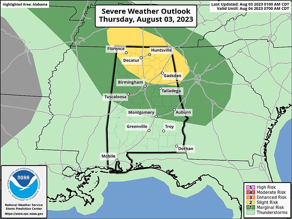
Thursday Outlook
Risk Areas
James Spann, ABC 33/40, and Townsquare Media Tuscaloosa Chief Meteorologist said that the Storm Prediction Center “has defined a "slight risk" (level 2/5) of severe thunderstorms for that part of Alabama north of a line from Russellville to Gardendale to Ranburne, and a "marginal risk" (level 1/5) as far south as Eutaw, Montgomery, and Phenix City.”
Potential Threats & Timing Outlook
As we monitor conditions, here are the potential threats and timing outlook according to the National Weather Service in Birmingham
Severe Thursday
Where: Much of Central Alabama, excluding counties across the far south. The best chance for severe storms will be within the Slight Risk area across the northern and northeastern counties.
When: Noon to 9 p.m.
Threats: Damaging winds up to 60 mph
Flooding
Where: Far northeast counties of Central Alabama, but could be expanded based on rainfall observed today
When: Through Noon Friday
Threats: Potential rainfall of up to 3 inches could cause localized flooding within the watch area

Friday Outlook
“There is potential for another mass of storms to move through Alabama tomorrow; there is a "marginal risk" (level 1/5) of severe thunderstorms for roughly the southern 2/3 of the state,” said Spann.
Severe Friday
Where: Southwestern half of Central Alabama
When: 10 a.m. to 7 p.m.
Threats: Damaging winds up to 60 mph

(Source) For more from the National Weather Service Birmingham, click here. For more from the Storm Prediction Center, click here. To follow the Facebook Page of James Spann, click here.
The Most Expensive Home in Alabama is a Coastal Masterpiece
Gallery Credit: Mary K
Lamar County Alabama’s Most Expensive Home Includes 112-Acre Farm
Gallery Credit: Mary K
Iconic One-of-a-Kind Smith Lake Alabama Castle Hits the Market
Gallery Credit: Mary K
Most Expensive Home in Hale County
Gallery Credit: Mary K
Exquisite Tuscaloosa Waterfront Home Has Hit the Market
Gallery Credit: Mary K
More From 92.9 WTUG


