Damaging Winds, Lightning Possible as Storms Move Across Alabama
5:15 p.m. Update
The National Weather Service has issued a Severe Thunderstorm Watch in effect until 10 p.m. for Greene, Lamar, Pickens, and Sumter counties in West Alabama.
4 p.m. Severe Weather Update
The National Weather Service in Birmingham has provided updates on the potential for strong to severe storms this evening.
Risk Areas
Portions of Alabama were upgraded to a Slight Risk, and other counties maintained a Marginal Risk.
West Alabama Counties Under Slight Risk
Fayette
Lamar
Pickens (a large portion of the county)
Tuscaloosa (a large portion of the county)
Walker
West Alabama Counties Under Marginal Risk
Bibb
Greene
Hale
Perry
Pickens (far southern portion of the county)
Sumter
Tuscaloosa (far southern portion of the county)
Severe Weather Threats
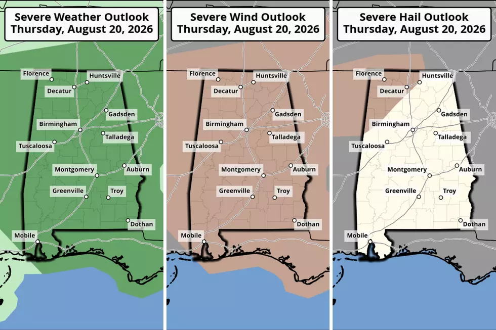
Damaging winds with gusts up to 60 mph are possible, and the forecast now includes the potential for large hail up to quarter-sized plus locally heavy rainfall.

Severe weather is possible today, Thursday, August 20, across all of Alabama. The Storm Prediction Center has West Alabama and the entire State under a “Marginal Risk” for strong-to-severe thunderstorms.
The National Weather Service in Birmingham said active weather for West Alabama is expected between 3 p.m. and 8 p.m., and the primary threat is isolated damaging winds with gusts up to 60 mph.
There is a 5 to 14% probability of severe winds according to the Storm Prediction Center. There is also a 5 to 14% probability of severe hail for portions of Alabama, including the following counties: Lamar, a portion of Fayette, and the very small northwest corner of Pickens.
“Heavier storms this afternoon and early tonight will be capable of producing strong wind gusts and lots of lightning,” said James Spann, Alabama Weather Network Chief Meteorologist. “Odds of any one spot getting wet today are 30/40 percent.”
READ MORE: West Alabama Gets Another Round of Hot and Humid Weather
Stay Weather Aware – Mary K. | Weather Forecaster
Alabama Department of Public Health Shares Heat Safety Tips
Gallery Credit: Mary K
Alabama Power Energy Savings Tips
Gallery Credit: Mary K
Heat-Related Weather Terminology
More From 92.9 WTUG