Tuscaloosa, Alabama Closely Monitoring Path of Tropical Storm Fred
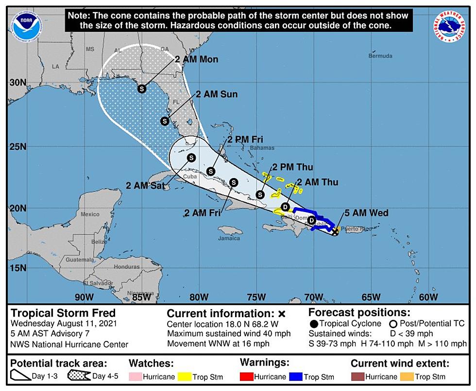
Late Tuesday night August 10, 2021, Tropical Storm Fred formed near Puerto Rico and is tracking through the Caribbean Sea. This is the 6th named storm of the 2021 Atlantic hurricane season. Current tracking by the National Hurricane Center shows that Tropical Storm Fred could move in a west-northwest direction.
According to the National Weather Service in Birmingham, “It remains too soon to pinpoint impacts to Central Alabama, if any, as we continue to assess the weather setup ahead of Fred; however, squally weather will occur along its path over the coming days.”
Projected Timeline (this can change)
This morning: Parts of the Dominican Republic could expect tropical storm conditions.
This afternoon-evening: Northern Haiti and the southeastern Bahamas could experience tropical storm conditions.
Friday: Florida could feel the impacts of wind and rainfall
This weekend: Those impacts will spread northward into the Peninsula and then Panhandle.
Watching Tropical Storm Fred
We are closely monitoring this system and what it could mean for Alabama. Tropical Storm Fred could weaken some and dissipate for a time after its interaction with Hispaniola. However, this system does have the potential to reorganize and strengthen once it gets closer to Cuba and the Bahamas.
Here are the current watches and warnings associated with Tropical Storm Fred from the National Hurricane Center:
A Tropical Storm Warning is in effect for...
* Dominican Republic on the south coast from Punta Palenque eastward and on the north coast from the Dominican Republic/Haiti border eastward
A Tropical Storm Watch is in effect for...
* Haiti from the northern border with the Dominican Republic to Gonaives
* Turks and Caicos Islands
* Southeastern Bahamas
A Tropical Storm Warning means that tropical storm conditions are expected somewhere within the warning area, in this case within the next 12 hours.
A Tropical Storm Watch means that tropical storm conditions are possible within the watch area.
Interests elsewhere in Haiti and the Bahamas, as well as in eastern and central Cuba, should monitor the progress of this system.
James Spann, ABC 33/40, and Townsquare Media Tuscaloosa Chief Meteorologist reminds us that the “4 and 5 day NHC track forecasts have average errors of 175 and 200 miles, respectively. Meaning, of course, the forecast of the track and intensity could easily change in coming days.”
(Source) Click here for more from the National Weather Service in Birmingham. Click here for more from the National Hurricane Center. Click here for more information from James Spann.
Ways to Receive Severe Weather Information
KEEP READING: Get answers to 51 of the most frequently asked weather questions...
KEEP READING: Get answers to 51 of the most frequently asked weather questions...
More From 92.9 WTUG