
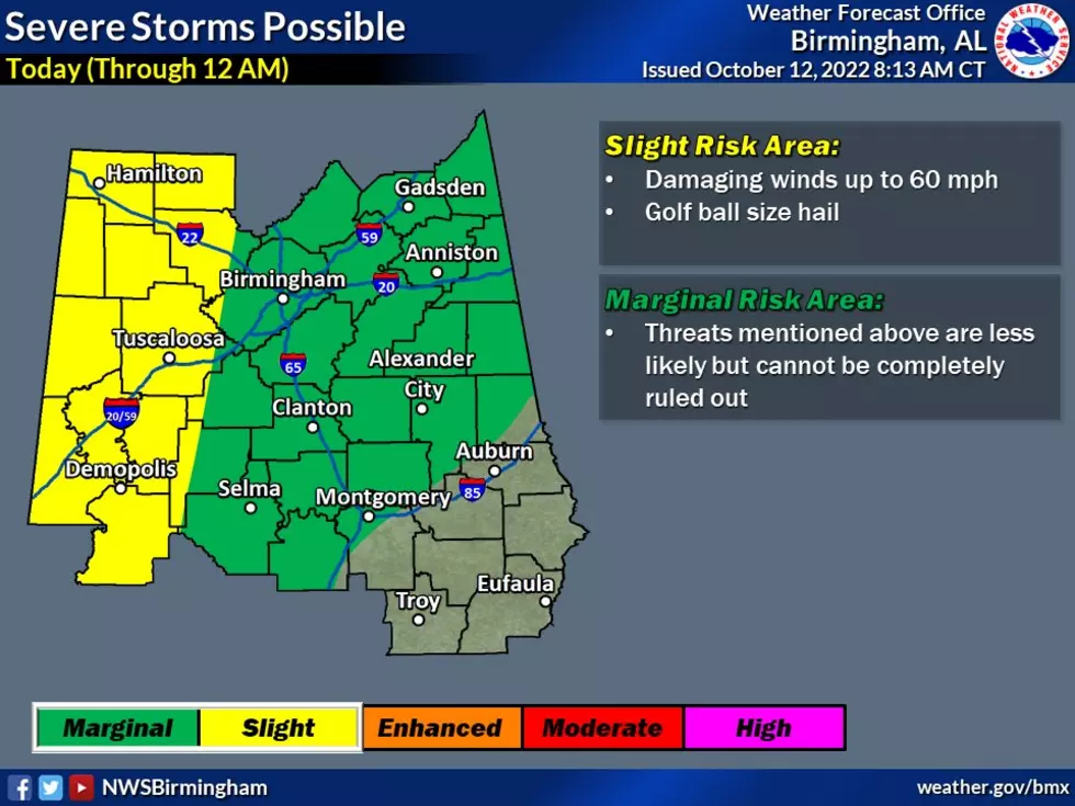
West, Central Alabama Under Marginal Risk for Severe Weather Today
We haven’t had a significant amount of rain in quite some time in the Yellowhammer State. Be sure to find your umbrella because we could see from ½ to 1 inch of rain from this system.
The National Weather Service in Birmingham said to expect “widespread showers and thunderstorms will move through the state in the afternoon and early evening, with a brief break in activity possible in the late evening before a frontal boundary brings more rain and thunderstorms around midnight.”
In addition, "there is a lot of energy allowing these storms to strengthen this morning. We have included a threat for golf ball size hail and increased the timing to include the morning hours for severe storms to be possible. Stay aware of the weather today," said the NWS.
Where:
Roughly along and north of I85.
When:
Wednesday 2 PM until midnight.
Threats:
Isolated damaging winds up to 60 mph.
(updated) > Golf Ball Size Hall

Storm Prediction Center (SPC) Risk Levels
Currently, the SPC has two sections of Alabama in either a “Slight Risk” or “Marginal Risk” area. Also, noting thunderstorms for those outside those two areas.
UPDATED INFO
The Townsquare Media Tuscaloosa coverage area is under the “Slight Risk” zone. Our radio stations cover Bibb, Fayette, Greene, Hale, Lamar, Perry, Pickens, Sumter, Tuscaloosa, and Walker counties.

James Spann, ABC 33/40, and Townsquare Media Tuscaloosa Chief Meteorologist said that the “main concern with heavier thunderstorms this afternoon and tonight will be from strong, gusty straight-line winds, but some small hail is possible as well."
"A brief, isolated tornado can't be totally ruled out in the "slight risk" area but overall this is a fairly low-end threat. But, as always, we will be watching radar trends closely. The main window for the heavier storms will come from about 4 p.m. until midnight," said Spann.
In times of severe weather, Townsquare Media Tuscaloosa is always closing monitoring the systems and will bring you all necessary updates. Also, if needed, we will bring you on-air updates on our local radio stations which are Praise 93.3, 92.9 WTUG, 95.3 The Bear, METV 97.5, Catfish 100.1, Tide 100.9, ALT 101.7, and 105.1 The Block.

(Source) For more from the National Weather Service Birmingham, click here. Click here to follow the Facebook Page for James Spann.
7 Tips For Driving in the Rain
Amazing and Intriguing Weather Folklore
Gallery Credit: Mary K
Amazing and Intriguing Weather Folklore
Gallery Credit: Mary K
More From 92.9 WTUG


