Risk for Severe Weather This Afternoon, Tomorrow in Alabama
We have been monitoring a weather system that has the potential to bring severe weather to our area later today and tomorrow. This severe weather threat started impacting West Texas on Tuesday and brought their area “hail the size of baseballs or even larger was reported in some storms,” said The Weather Channel.

This system will travel towards Alabama crossing over Louisiana, Mississippi, Florida Panhandle, and portions of Georgia.

What Can We Expect From This System?
Wednesday
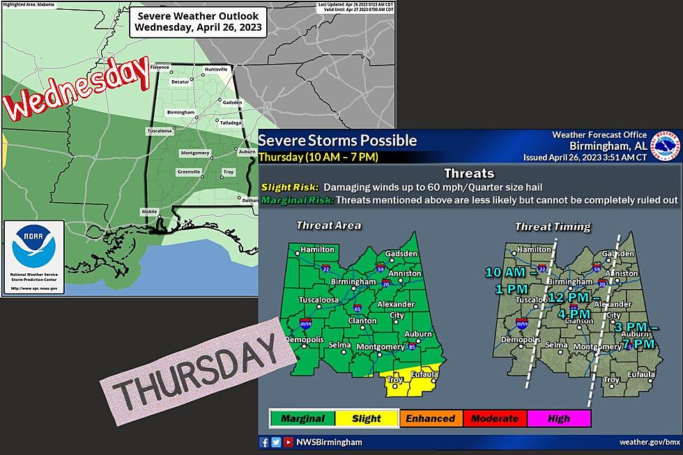
Today, the Storm Prediction Center has “introduced a very low end, "marginal risk" of severe thunderstorms for parts of Central and South Alabama this afternoon; a few storms could produce small hail and gusty winds. No tornado threat today,” said James Spann, ABC 33/40, and Townsquare Media Tuscaloosa Chief Meteorologist.

Thursday
Tomorrow, the Storm Prediction Center has “defined a "slight risk" (level 2/5) of severe thunderstorms for South Alabama for areas south of a line from Grove Hill to Greenville to Eufaula. A "marginal risk" (level 1/5) extends as far north as Decatur and Huntsville,” said Spann.
The National Weather Service in Birmingham Threats for Thursday
"Slight Risk" Threats
Damaging winds up to 60 mph
Quarter Size Hail
"Marginal Risk"
Threats mentioned above are less likely but cannot be completely ruled out

Spann said that “the core threat of heavier storms will be over the southern quarter of the state, where the air will be most unstable. The main threats will come from small hail and strong straight-line winds, but an isolated tornado can't be ruled out, especially across Mobile and Baldwin counties. Rain will be heavy at times across South Alabama, where rain amounts could exceed one inch.”
Northern Half of the State
The risk of severe thunderstorms over the northern half of the state is low, and there is no tornado threat there. Rain amounts over North Alabama will be generally 1/2 inch or less.
Timing
The main window for the overall weather system is between 10 a.m. and 7 p.m. For our Townsquare Media Coverage area, the timing is between 10 a.m. and 1 p.m. and then another section is from Noon until 4 p.m.
Please remember that as weather conditions change the timing could change as well.
County-by-County Timing
Bibb: Noon to 4 p.m.
Fayette: 10 a.m. to 1 p.m.
Greene: 10 a.m. to 1 p.m.
Hale: 10 a.m. to 1 p.m.
Lamar: 10 a.m. to 1 p.m.
Perry: Noon to 4 p.m.
Pickens: 10 a.m. to 1 p.m.
Sumter: 10 a.m. to 1 p.m.
Tuscaloosa: The majority of this county is in the 10 a.m. to 1 p.m. with a small portion that extends past 1 p.m.
Walker: The majority of this county is in the 10 a.m. to 1 p.m. with a small portion that extends past 1 p.m.

As new weather information becomes available or any changes to the outlook, we will be sure to update you.
(Source) For more from the National Weather Service Birmingham, click here. Click here to follow the Facebook Page for James Spann. Click here for more details from The Weather Channel.
LOOK: 25 must-visit hidden gems from across the US
Gallery Credit: Abby Monteil
LOOK: Must-do activities at every national park
Gallery Credit: Angela Underwood
LOOK: Famous Historic Homes in Every State
More From 92.9 WTUG