
Wednesday’s Severe Weather Risk Includes Unusual Tornado Threat
The past few days our area has faced multiple rounds of severe weather and will continue into Wednesday.
The National Weather Service in Birmingham, said “several rounds of severe thunderstorms posing a threat for large/damaging hail, damaging winds, flooding, and perhaps a tornado.”
Yes, Tornado, which is unusual for this time of the year.
Risk Areas
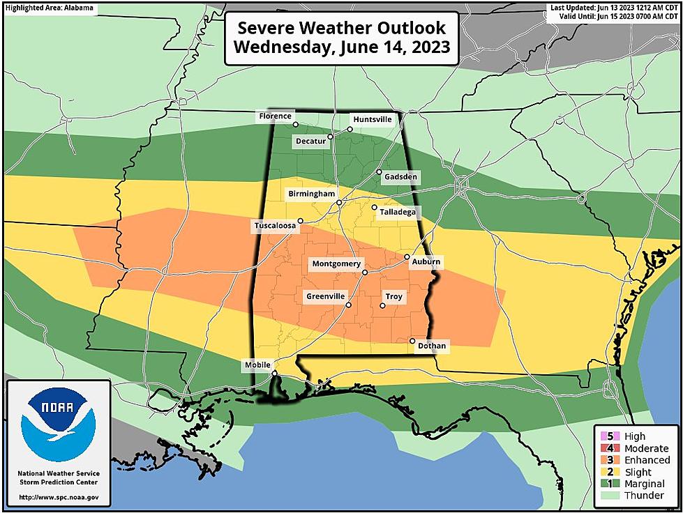
James Spann, ABC 33/40, and Townsquare Media Tuscaloosa Chief Meteorologist said that the Storm Prediction Center for Wednesday has now “defined an "enhanced risk" (level 3/5) for parts of Central and South Alabama, including cities like Demopolis, Selma, Montgomery, Greenville, Monroeville, Troy, and Eufaula. "Slight" and "marginal" risks surround the enhanced risk to cover much of the state.”

Concerning Threats for Wednesday
Damaging winds up to 70 mph
Hail up to baseball size (2.75")
Flooding
Perhaps a Tornado

“Hail and strong winds remain possible with the heavier thunderstorms tomorrow, and with unusually strong wind fields for June, an isolated tornado or two can't be totally ruled out, especially in the enhanced risk area,” said Spann.
Timing
As of right now, the National Weather Service in Birmingham believes that the highest potential for a tornado could occur Wednesday evening into the overnight hours on Thursday.
(Source) For more from the National Weather Service Birmingham, click here. For more from the Storm Prediction Center, click here. To follow the Facebook Page of James Spann, click here.
QUIZ: Can you identify 50 famous companies by their logos?
KEEP LOOKING: See what 50 company logos looked like then and now
Here are 50 of your favorite retail chains that no longer exist.
More From 92.9 WTUG


