What Alabamians Need to Know About Sally
[Update provided on Wednesday, September 16, 2020, at 4 pm]
We are continuing to monitor Sally and the impacts on Alabama. Our thoughts are going out to those directly affected by Sally. We are in awe of the damage and epic flooding that is taking place along the Alabama coast. Please continue to think of our fellow Alabamians.
For our listening areas:
- The rain will be moving out of Alabama later tonight
- Substantial rain is occurring in the southeast part of Alabama
- The tornado threat is for the southeast corner of the state

What Alabamians Need to Know About Sally [from earlier today]
- Impacts of Sally to inland Alabama are south of our listening areas.
- The winds and rains related to Sally will remain south of I-59.
- Central Alabama could see sustained winds up to 30 mph with gusts up to 45 mph
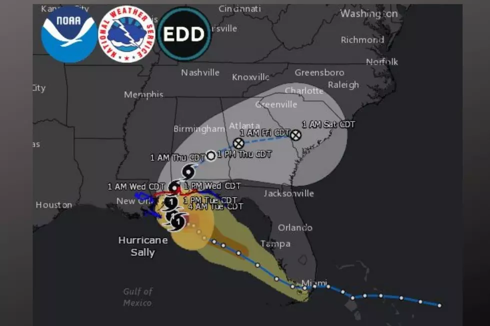
Sally made landfall near Gulf Shores, Alabama. At the time of its impact, Sally was a category two hurricane, and there were sustained winds of 105 miles per hour. Landfall took place around 4:45 am Tuesday, September 16, 2020. The main threats are catastrophic and life-threatening flooding along portions of the northern Gulf Coast.
Impacts to West and Central Alabama:
- The track of Sally moving forward should turn northeastward and should move across the Southeast through Friday. As initially thought, this impacts our listening areas.
- Sally is expected to weaken, and gain speed has into moves inland across Alabama today and into early Thursday.
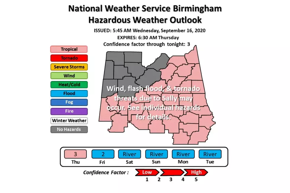
- Hazardous Weather Outlook (look below for counties) through tonight.
- Flash Flooding potential – Flash Flood Watch (look below for counties as some have been canceled)
- River Flooding potential
- Wind Advisory (see below for counties) through tomorrow at 7 am.
- The potential for isolated tornadoes could take place in southern Alabama. There is a marginal tornado threat this afternoon into this evening from noon through 11 pm along and south of the Interstate 85 corridor.
Hazardous Weather Outlook through tonight for the following counties: Marion-Lamar-Fayette-Winston-Walker-Blount-Etowah-Calhoun-Cherokee-Cleburne-Pickens-Tuscaloosa-Jefferson-Shelby-St. Clair-Talladega-Clay-Randolph-Sumter-Greene-Hale-Perry-Bibb-Chilton-Coosa-Tallapoosa-Chambers-Marengo-Dallas-Autauga-Lowndes-Elmore-Montgomery-Macon-Bullock-Lee-Russell-Pike-Barbour.
According to the National Weather Service, these are possible impacts, ”the southern half of the area will see wind impacts with sustained winds of 15 to 30 mph and gusts up to 45 mph. Heavy rains along a line generally south of Interstate 59 may cause flash flooding today and tonight. There will also be a marginal tornado threat this afternoon into this evening from noon through 11 pm along and south of the Interstate 85 corridor.”
Flash Flood Watch is CANCELLED for the following counties: Blount, Jefferson, Greene, Sumter, and Tuscaloosa
Flash Flood Watch in effect now through 1 pm Thursday for the following counties; Portions Of Central Alabama...East Central Alabama...Northeast Alabama...Southeast Alabama And West Central Alabama, Including The Following Areas, In Central Alabama, Autauga, Bibb, Chilton, Coosa, Dallas, Elmore, Lowndes, Montgomery, Perry, Shelby, St. Clair, and Talladega. In East Central Alabama, Calhoun, Chambers, Clay, Cleburne, Lee, Macon, Randolph, Russell, and Tallapoosa. In Northeast Alabama, Cherokee and Etowah. In Southeast Alabama, Barbour, Bullock, and Pike. In West Central Alabama, Hale and Marengo.
Wind Advisory until 7 am on Thursday for the following counties: Sumter, Greene, Hale, Bibb, Chilton, Coosa, Tallapoosa, and Chambers.
According to the National Weather Service, “northeast winds 15 to 25 mph with gusts up to 35 mph. The impacts of gusty winds could blow around unsecured objects. Tree limbs could be blown down, and a few power outages may result.”
Wind Advisory until 7 am on Thursday for the following counties: Perry-Marengo-Dallas-Autauga-Lowndes-Elmore-Montgomery-Macon-Bullock-Lee-Russell-Pike-Barbour.
According to the National Weather Service, “east winds 20 to 30 mph with gusts up to 45 mph. The impacts of gusty winds could blow around unsecured objects. Tree limbs could be blown down, and a few power outages may result.”
Impacts to the Alabama Coast:
(At the time of this story) According to Power Outage US, for “Alabama, there were 241, 037 power outages.” These outages are coming from the following counties “Baldwin, Clarke, Conecuh, Escambia, Mobile, Monroe, and Washington.”
Near Sally’s center, there is storm surge flooding taking place near and to the east. Pensacola, Florida, has reports of storm surge over five feet.
Southeast Alabama has experience flash flooding, leading to flooded roads and homes.
Up to 25 inches of rain for Southern Baldwin County.
(Source) For more information from Power Outage US, click here. For more from the National Weather Service, click here.
Clouds: Artwork In The Sky
More From 92.9 WTUG


![Hurricane Sally Impacts Alabama’s Coast [Video]](http://townsquare.media/site/534/files/2020/09/RS8359_466693533.jpg?w=980&q=75)