Alabama Braces for a Deep Freeze and the Potential for Snowflakes
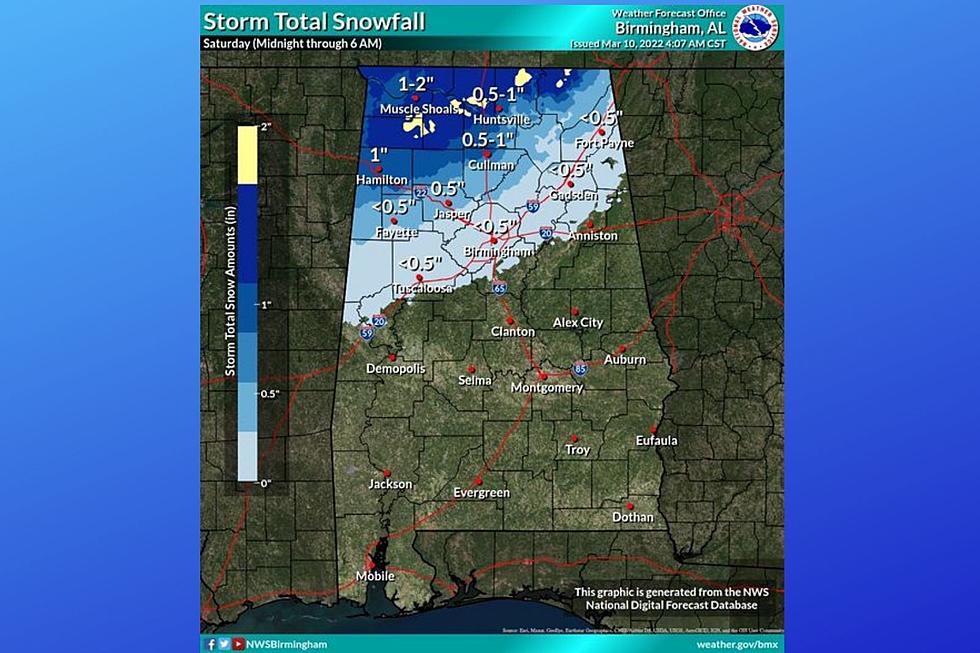
Be sure to dig out your big winter coat because you are going to need it this weekend along with your gloves and winter hats. Rain from a storm system that will move across the area Friday into Friday night could transition to snow in the northern Central Alabama counties with some accumulation expected.
Windy Conditions
In addition, there is a chance for windy conditions that could lead to the possibility of downed trees and powerlines.
Traveling
For those traveling throughout the Yellowhammer State on Friday evening, please make sure you are aware of the severe weather threat for Southeast Central Alabama which is along and south of Interstate 85.
Deep Freeze
Very cold weather will move in our coverage areas on Saturday. James Spann, ABC 33/40, and Townsquare Media Tuscaloosa Chief Meteorologist said that “the sky will clear during the day Saturday, but temperatures hold in the 30s over the northern half of the state with wind chill indices near freezing all day.” On Sunday the temperatures could drop into the 20s for all of Central Alabama.
National Weather Service in Birmingham Highlights
Where:
Winter: Northern Central Alabama (Along and north of Interstate 20)
Wind: All of Central Alabama
Cold Weather: All of Central Alabama
When:
Winter: Midnight Saturday morning through 6 am Saturday morning
Wind: Midnight Saturday morning through Saturday evening
Cold Weather: Saturday, Sunday, and Monday mornings
Threats:
Winter: Slippery conditions on elevated surfaces, minor accumulations up to an inch far north
Wind: Sustained winds 15-20 mph with gusts up to 40 mph could lead to downed trees and power outages.
Cold Weather: Widespread freezing conditions could impact vulnerable populations and damage sensitive vegetation.
Will there be any Snow Accumulations?
Spann noted that “higher accumulation probabilities are along and north of U.S. 278 (Hamilton to Cullman to Gadsden), where some spots could see 1-2 inches on grassy areas (roads will be just wet). Snowflakes are likely down to Tuscaloosa/Birmingham/Anniston, but odds of meaningful accumulation are low that far south. Accumulation potential will be limited by warm soil temperatures; remember we will be in the 70s tomorrow afternoon before the snow arrives.
As temperatures drop below freezing, a few slick spots are possible on bridges across the Tennessee Valley of North Alabama Saturday morning. For now, travel impact is not expected for places like Birmingham, Tuscaloosa, and Anniston.”
(Source) For more from the National Weather Service Birmingham, click here. Click here to follow the Facebook Page for James Spann.
LOOK: See how much gasoline cost the year you started driving
